LandEX: Improving Landscape resilience by integrating measures to adapt and mitigate hydrological EXtremes
Welcome to the LandEX project. The overall aim of LandEX is to improve landscape resilience to hydroclimatic extremes (floods and droughts), by spatially optimising a suite of adaptation measures in the landscape. The project proposes to achieve this by applying connectivity-based hydrological models and by designing adaptation scenarios in close collaboration with local stakeholders. The knowledge gaps that the project addresses include:
- How different (NBS) measures can increase water retention in the landscape and, thus, mitigate floods and droughts;
- How their spatial location affects and determines their effectiveness at the landscape level, and
- Potential synergies between a network of different measures located on different parts of the landscape to maximise both floods and droughts mitigation.
To address these knowledge gaps LandEX aims to achieve the following objectives, addressed in specific Work Packages (WP):
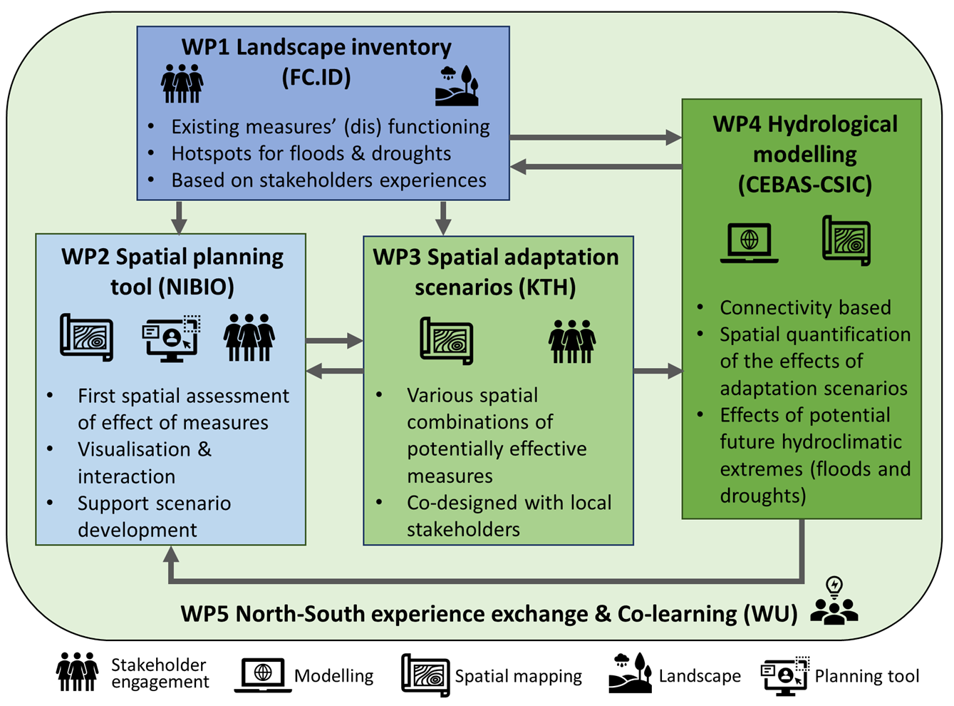
LandEX Work Packages
WP1: Investigate in each study area (i) the current hotspots for flood and drought occurrence; (ii) how existing flood and drought mitigation measures perform and/or why they are not effective, both technically and socioeconomically; and (iii) potential synergies of (NBS) measures to mitigate both floods and droughts.
WP2: Develop a spatial planning tool (online map interface) that visualises the effects of measures spatially within the landscape and supports stakeholders to develop spatial management plans to optimize landscape resilience to hydroclimatic extremes.
WP3: Co-design spatial adaptation scenarios of feasible and potentially effective suites of measures in the landscape, in close collaboration with local stakeholders.
WP4: Quantify the effectiveness of the spatial adaptation scenarios (from WP3) on floods and droughts using spatially-explicit hydrological models.
WP5: Stimulate co-learning between the 5 study areas by enabling exchange of experiences regarding problems and implemented and innovative adaptation measures to hydroclimatic extremes. Through these objectives LandEX is expected to contribute to mitigating the impact of floods and droughts on society, by helping water managers design effective spatial adaptation scenarios with the collaboration of landowners.
Project Partners
Discover the collaborating institutions and researchers driving the LandEX project forward.
Study Areas
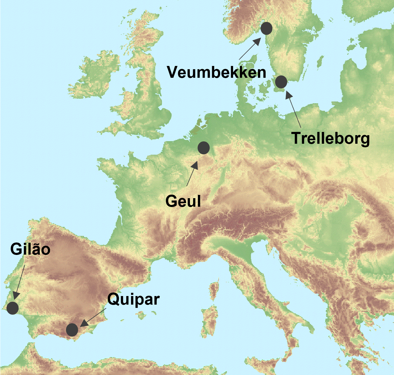
The LandEX project is performed in five study areas in Norway, Portugal, The Netherlands, Spain and Sweden. See the map below for the locations of the study areas.
 Explore Study Areas →
Latest Output
- Strategic placement of nature-based solutions for ecosystem service delivery through landscape connectivity and participatory decision support
- Strategic NbS Placement & Evaluation
- Mitigation of pluvial flooding using NBS Scenarios: An OpenLISEM based case study for Fredrikstad